GPS vs GLONASS vs Galileo: Which One Is More Accurate in 2026?
Ever noticed your GPS photos showing the wrong location or drifting in crowded cities? One minute you are capturing an image on a construction site, and the next, your photo's EXIF metadata says you are standing in the middle of a river three blocks away.
This frustrating phenomenon is known as "GPS drift," and it is the enemy of accurate field reports and compliance documentation. However, there is a technical secret working behind the scenes: your modern smartphone is no longer just using "GPS" to find your location. It is utilizing Multi-GNSS accuracy to aggregate signals from space and stay pinpoint precise.
In this technical deep-dive, we will explore exactly how location tracking works in modern smartphones and compare the major global satellite constellations. Whether you are inspecting a property with an iPhone 15 Pro or surveying land with a Samsung Galaxy S24, understanding the GNSS vs GPS difference is critical for anyone who relies on geotagged photos for legal proof.
Technical Index
GNSS vs GPS: Understanding the Difference
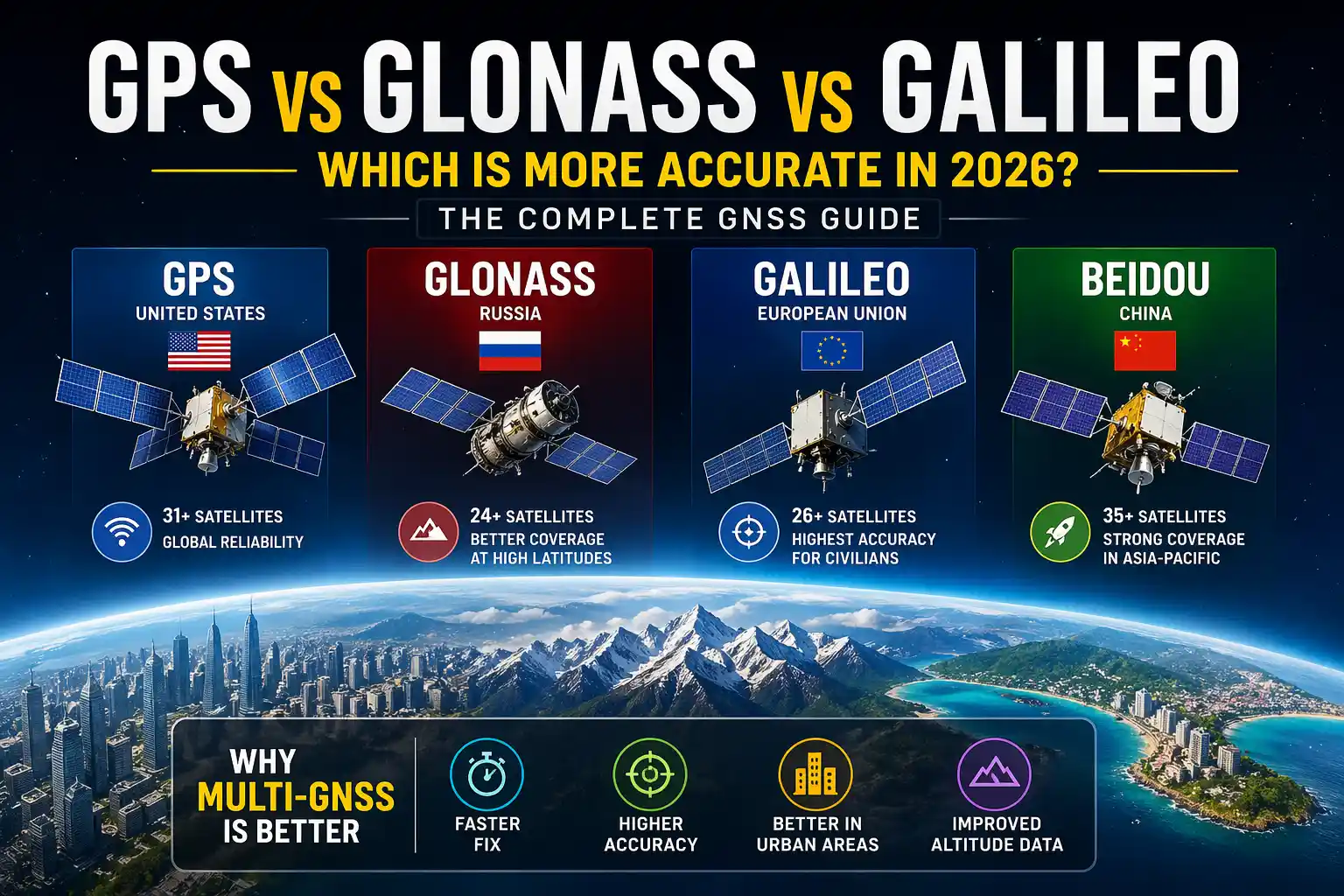
While society colloquially uses "GPS" as a catch-all term for location tracking, GPS (Global Positioning System) is actually just one specific satellite network owned and operated by the United States government. The correct, overarching technical term is GNSS (Global Navigation Satellite System).
To calculate a 3D position (latitude, longitude, and altitude), a receiver needs an unobstructed line of sight to at least four satellites. In the early 2010s, smartphones only had access to the 31 satellites in the US GPS network. If a building blocked the signal, your location dropped.
Today, your device is an authority on multi-GNSS accuracy. Modern smartphone chipsets "listen" to multiple constellations simultaneously. By aggregating signals from American, European, Russian, and Asian satellites, your phone suddenly has over 100 satellites to choose from. This synergy is what allows for a "lock" in milliseconds rather than minutes, providing unprecedented reliability even in challenging environments.
Deep Dive: The 4 Major Satellite Constellations
When you use a tool like our GPS Photo Editor to correct a drifting coordinate, the location data you are embedding is derived from one (or a combination) of these four massive engineering achievements:
1. NAVSTAR GPS (United States)
GPS is the original pioneer and the global baseline for all modern navigation. Operating at an altitude of 20,200 km, the system relies on 31 active satellites. While older civilian GPS signals had a margin of error of around 3 to 5 meters, recent upgrades (like the GPS Block III satellites) have significantly improved signal strength and anti-jamming capabilities.
2. Galileo (European Union)
Launched by the European Space Agency, Galileo is arguably the most accurate GNSS for civilians today. Unlike GPS or GLONASS, which were built strictly for military operations first, Galileo was designed from the ground up for commercial and civilian use. According to the European Union Agency for the Space Programme, Galileo's High Accuracy Service (HAS) provides sub-meter precision (often down to 20cm), marking a 300% improvement over older GPS standards.
3. GLONASS (Russia)
GLONASS uses 24 satellites operating in a slightly different orbital geometry than GPS. Its satellites have a higher orbital inclination (64.8 degrees), which means they pass higher over the Earth's poles. If you are documenting sites in high-latitude regions like Northern Europe, Canada, or Alaska, GLONASS provides a much better angle of incidence than GPS, making it essential for Arctic precision.
4. BeiDou (China) & NavIC (India)
With over 35 active satellites, China's BeiDou is currently the largest constellation in orbit. It utilizes a mix of Medium Earth Orbit (MEO) and Geostationary Earth Orbit (GEO) satellites, offering incredible density in the Asia-Pacific region.
Regional Precision: The Rise of NavIC
Modern smartphone chips (like the Snapdragon 8 Gen series) now support NavIC (Navigation with Indian Constellation). Because NavIC utilizes S-band frequencies alongside the standard L-band, it is highly resistant to atmospheric interference, providing superior precision over the Indian subcontinent, especially in densely forested or mountainous terrain.
The Game Changer: Dual-Frequency GNSS (L1 + L5)
Having more satellites is great, but the biggest breakthrough in how GPS works in phones involves how the signals themselves are processed. Historically, civilian GPS used a single radio frequency band called L1.
The problem with L1 is the Earth's ionosphere. When satellite signals pass through the charged particles of the upper atmosphere, they slow down. This delay ruins the mathematical timing required to calculate a precise location.
To fix this, modern flagships (like the iPhone 15 Pro, Samsung S24 Ultra, and Google Pixel 8) use a second, distinct frequency band called L5 (or E5a for Galileo). Because the ionosphere slows down L1 and L5 signals at slightly different rates, a dual-frequency phone can compare the difference between the two signals, calculate the exact atmospheric delay, and mathematically cancel it out. This "Ionospheric Correction" delivers lane-level accuracy.
The Urban Canyon Effect and Multipath Interference
If you have ever seen your location pin jump aggressively across the street while you are standing still, you have experienced "Multipath Interference."
When you stand between skyscrapers (an urban canyon), the direct line-of-sight to the satellite is blocked. The signal bounces off glass and steel facades before reaching your phone. Because the signal took a longer, bouncing path, your phone's math thinks the satellite is further away than it actually is, throwing your coordinates into chaos.
Multi-GNSS solves this. By having 30+ satellites in view rather than just 4, the receiver can afford to be selective. Its algorithms can identify signals that look like delayed reflections, ignore them entirely, and focus only on the direct, line-of-sight data.
Real-World Accuracy Comparison Matrix
How much accuracy do you actually need? For casual travel, 10 meters is fine. But for site inspections and legal compliance, anything over 3 meters is a liability. Here is a breakdown of what to expect in 2026:
| Scenario / Environment | Standard GPS (L1 Only) | Multi-GNSS + L5 (Modern Device) |
|---|---|---|
| Open Sky (Rural/Field) | 3.5m – 7.8m | 0.3m – 1.2m |
| High-Latitude (Arctic/Canada) | Weak / Inconsistent | Strong (GLONASS Optimized) |
| Urban Canyons (Skyscrapers) | 15m – 40m (High Drift) | 3m – 5m (Stable) |
| Deep Foliage (Forests) | Signal Dropouts | Reliable Multi-Path Lock |
Why GNSS Matters for Photo EXIF Metadata
When you take a photo for a compliance report or a field survey, the exact latitude and longitude active at the millisecond the shutter closes are permanently written into the image's EXIF data. If your phone is experiencing multipath interference or a weak L1 signal at that exact moment, the photo becomes legally useless.
Because EXIF data is invisible and easily stripped during sharing, relying on raw background tracking is risky. This is why field professionals use tools like our GPS Map Camera Online. By pulling the highest-accuracy aggregate data from your browser's location API, our tool allows you to visually verify the multi-GNSS coordinates on a live map before permanently burning a visible stamp onto the image pixels.
Frequently Asked Questions
Add High-Accuracy GPS Stamps to Your Photos
Harness the full power of Multi-GNSS accuracy to professionalize your field reports. Fast, free, and secure directly in your browser without installing any apps.
Try Free GPS Photo Tool Now
Priyanshu built GPS Map Camera Online after running into privacy issues and slow performance with traditional mobile GPS camera apps. He specialises in browser-based tools for field documentation and photo geotagging — keeping everything fast, private, and free.
View all posts →