How to Use GPS Photos for Legal & Insurance Proof: A 2026 Checklist
In the legal and insurance sectors, the phrase "a picture is worth a thousand words" only holds true if you can prove exactly where, when, and how that picture was taken. In 2026, standard digital photos are increasingly being rejected or heavily scrutinized by insurance adjusters and opposing legal counsel because they are simply too easy to manipulate.
If you are documenting a vehicle accident, a property boundary dispute, or a catastrophic construction failure, you cannot rely on a basic smartphone snapshot. You need a "Bulletproof Image." Using tools like the GPS Map Camera Online utility adds critical layers of irrefutable data by merging image pixels with satellite-verified coordinates and real-time maps.
Table of Contents
The Evolution of Digital Evidence
Gone are the days when a simple timestamp in the corner of a digital photo was enough for a court of law. With the exponential rise of AI-generated imagery and advanced photo-editing software, "visual proof" faces immense skepticism.
Attorneys and insurance fraud investigators now look for multi-layered verification. An image must have geographical context that matches the physical lighting, weather, and structural reality of the scene. By physically burning location and time data into the pixels of the image, you create a composite document that is exceptionally difficult to forge without leaving forensic digital artifacts.
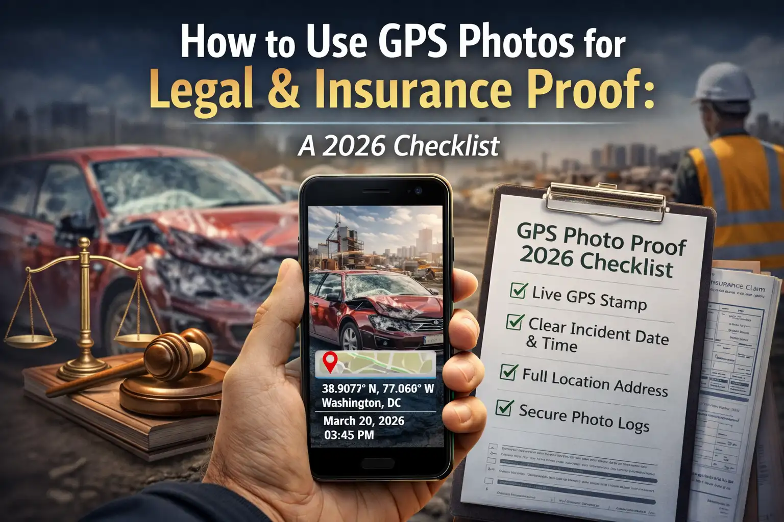
The 5-Point GPS Photo Checklist
If you are capturing photos for potential legal arbitration or high-value insurance claims, follow this rigorous checklist to ensure your evidence is admitted without question:
1. Verifiable Geolocation Precision
Ensure your Latitude and Longitude are displayed to at least 6 decimal places (e.g., 26.144512°). This allows an investigator or surveyor to pinpoint your exact standing position within a 1-meter radius, leaving no doubt about your vantage point.
2. Physical Address Overlay
While raw coordinates are required for technical verification, addresses are required for human context. Having a stamp that displays the nearest reverse-geocoded street address (e.g., "123 Main St, Guwahati, Assam") provides immediate clarity that makes the photo easier to interpret for judges, juries, and non-technical stakeholders.
3. Real-Time Map Inset
A stamp layout that includes a mini-map thumbnail proves that the device's GPS sensor and the visual surroundings align perfectly. This is a massive high-trust signal for insurance adjusters verifying remote property damage.
4. Network-Synced Timestamp
Never rely on a device's internal manual clock, as it can be easily changed in settings to fake a timeline. Our photo editor utilizes accurate network time formats (UTC/Local) to ensure the timestamp reflects the actual global time of the occurrence.
5. The "Wide and Tight" Context Rule
Always take one close-up shot of the specific issue (the dent, the broken pipe, the boundary line) and one wide-angle shot showing the surrounding unmovable landmarks (street signs, permanent buildings). Use the GPS stamp on both to prove they were captured at the exact same location consecutively.
Why Visual Stamps Win in Court
When an attorney presents a standard photo in court, the opposition may easily claim the location metadata was "faked" using an EXIF editor before submission. While hidden metadata is incredibly easy to alter, a visual stamp—one that is permanently rendered into the image pixels—requires significant, highly detectable forensic effort to modify.
Furthermore, standard EXIF data is almost always stripped automatically when a photo is emailed to a lawyer or sent to an adjuster via a messaging app. Visual stamps survive all file transfers. This visual transparency creates a "Document of Truth" that speaks for itself. For more on this, read our guide on adding location without EXIF dependencies.
Best Practices for Insurance Claims
If you are filing a claim for property damage following a natural disaster or a vehicle accident, speed and accuracy dictate your payout timeline. Using a browser-based GPS camera allows you to capture undeniable evidence immediately before vehicles are moved by police or emergency repairs begin.
Most major insurers in 2026 feature automated claim portals. Uploading images that already have visual GPS verification stamped on them often bypasses secondary manual reviews, speeding up your claim resolution significantly.
Chain of Custody & Data Integrity
The golden rule of legal photography is: Never edit the original photo payload.
If you use our tools to document a scene, keep the raw, unstamped original image securely backed up alongside the stamped version. Our utility is built on privacy-first, client-side processing. This means the "chain of custody" of your image remains entirely local to your device; it never touches a third-party server. As we highlight in our comparison of Online Tools vs Mobile Apps, keeping your data off random app servers is critical for maintaining the legal purity of your evidence.
Legal Photography FAQs
Document your evidence with confidence
Generate verifiable, professional GPS-stamped photos for free. No signup, no app, just unshakeable proof.
Start Documenting Now
Priyanshu built GPS Map Camera Online after running into privacy issues and slow performance with traditional mobile GPS camera apps. He specialises in browser-based tools for field documentation and photo geotagging — keeping everything fast, private, and free.
View all posts →