How GPS Works in Smartphones: Simple GPS Guide for Photographers (2026)
Every time you take a photo with location enabled, your smartphone quietly records where that image was captured. But how does your phone actually know your exact location?
Most people use GPS daily without thinking about what happens behind the scenes. Whether you are opening Google Maps, checking your ride-sharing app, or taking a location-tagged image, your phone is constantly communicating with satellites and nearby networks to determine your position.
For photographers, travelers, survey teams, inspectors, and field workers, understanding GPS matters more than ever. Modern smartphones can attach location data directly to photos, helping organize memories, document job sites, and create proof-based records. Many professionals now use tools like GPS Map Camera Online to place visible GPS details directly onto images for easier sharing and verification.
For photographers and field professionals using GPS location-stamped photos, understanding this process helps you capture more accurate and reliable data.
In this guide, we will break down how GPS works in smartphones in a simple, practical way — without unnecessary technical complexity.
Table of Contents
What Is GPS?
GPS (Global Positioning System) is a satellite-based navigation system that helps your phone determine its exact position on Earth.
It works using a network of satellites orbiting the planet. Your phone receives signals from multiple satellites and calculates your location based on distance and timing.
How GPS Works in Smartphones
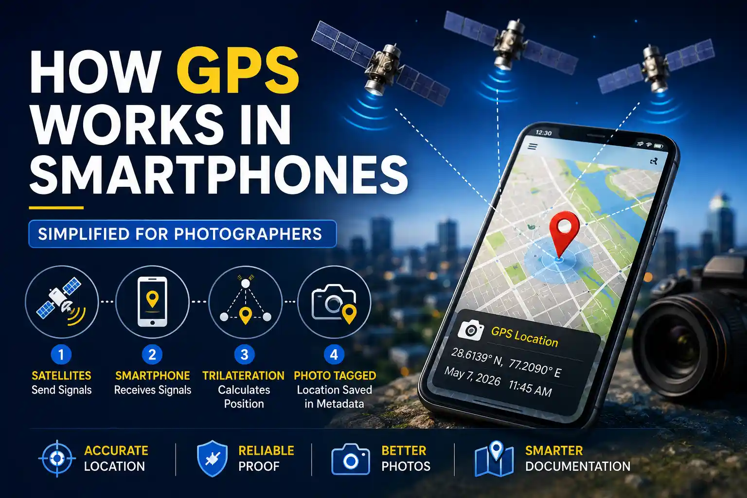
At its core, GPS works through timing and distance calculations. Satellites orbiting Earth continuously broadcast their exact position and current time. Your smartphone listens to these signals and measures how long they take to arrive.
Because radio signals travel at the speed of light, even tiny timing differences help the phone estimate distance from each satellite. Once the phone has enough distance measurements, it calculates your exact position using a mathematical method called trilateration.
The process happens extremely quickly and continuously in the background while you move.
Your smartphone does not send signals to satellites — it only receives them. Here's a simplified explanation:
- Your phone connects to at least 3–4 satellites
- Each satellite sends its position and time
- Your phone calculates distance from each satellite
- Using trilateration, it determines your exact location
Modern phones don’t rely only on GPS. They also use multiple systems like GLONASS, Galileo, and BeiDou. You can learn more in our GNSS comparison guide.
At GPS Map Camera Online, we analyze how smartphone location systems behave in real-world photography workflows, especially for field documentation and GPS-stamped reporting.
Why GPS Accuracy Varies
Many users assume GPS is always perfectly accurate, but real-world conditions can affect signal quality significantly. Some days your phone may show almost perfect precision, while other times the location may drift by several meters.
This variation happens because satellite signals are relatively weak by the time they reach Earth. Obstacles and environmental conditions can interfere with them before your device processes the data.
GPS is powerful, but it is not always perfectly accurate. Several factors affect it:
- Buildings: Signals reflect and cause errors in cities
- Weather: Atmospheric conditions can slightly affect signals
- Satellite visibility: Fewer satellites = lower accuracy
- Device quality: Better phones have better GPS chips
This is why your photo location might sometimes drift slightly.
What Is A-GPS?
Assisted GPS (A-GPS) improves speed and accuracy by using mobile networks and WiFi.
Instead of waiting for satellite data, your phone gets assistance from nearby cell towers and internet data to estimate location faster.
Simple explanation
GPS = accurate but slower. A-GPS = faster with network help.
How GPS Is Used in Photography
GPS has become a major part of modern smartphone photography. When location permission is enabled for the camera app, the phone stores coordinates inside the image file itself.
This information becomes part of the image metadata, often called EXIF data. Depending on the phone and app, the metadata may include:
- Latitude and longitude
- Date and time
- Altitude
- Device model
- Camera settings
Photo apps later use this information to organize images by place and date automatically.
When you take a photo with location enabled:
- Your phone captures GPS coordinates
- The data is stored inside the image as EXIF metadata
- Apps can read and display this location later
This is useful for travel, documentation, inspections, and proof-based photography.
Limitations of GPS in Photos
Even though smartphone GPS technology has improved massively, it still has some practical limitations that photographers should understand.
One of the biggest issues is metadata loss. Many messaging apps and social media platforms remove GPS data automatically during upload or sharing. This means the recipient may receive the photo but lose all hidden location information attached to it.
This is one reason why professionals increasingly prefer visible location stamps instead of depending entirely on hidden EXIF metadata.
Even though GPS is useful, it has limitations:
- Location data can be lost during sharing
- EXIF metadata can be removed or edited
- GPS may be inaccurate indoors
- Location may not be recorded if permissions are off
If your data disappears, you can try to recover lost GPS metadata using proper methods.
Best Practices for Accurate GPS Photos
If you regularly capture photos for work, documentation, or travel records, a few simple habits can improve GPS accuracy significantly.
Before taking important photos, open your maps app briefly and allow the phone to establish a strong GPS lock. This often improves coordinate precision immediately.
You should also avoid rapidly switching between airplane mode and location services while taking photos because the phone may need extra time to reconnect to satellites.
For documentation-heavy workflows such as inspections or construction reporting, visible overlays are often more reliable than hidden metadata alone. Many users use GPS Map Camera Online to permanently display coordinates, timestamps, and maps directly on images.
To get the best results:
- Enable location services before taking photos
- Wait a few seconds for GPS lock
- Avoid indoor or blocked environments
- Use visible stamps for important documentation
For critical use cases like construction or inspections, visible stamps are more reliable. Read our legal proof guide to understand why.
Pro Tip
Always verify location accuracy before capturing important photos — especially for professional or legal use.
Frequently Asked Questions (FAQ)
Want Accurate GPS-Stamped Photos?
Use our browser-based tool to add precise location, date, and map stamps directly onto your images.
Open GPS Map Camera Editor